Snow mass estimates now more reliable
Estimating the amount of seasonal snow is important for understanding the water cycle and Earth’s climate system, but establishing a clear and coherent picture of change has proven difficult. New research from ESA’s Climate Change Initiative has helped to produce the first reliable estimate of snow mass change and has helped to identify different continental trends.
Warming surface temperatures are known to have driven substantial reductions in the extent and duration of northern hemisphere snow cover. Equally important, but much less well understood is snow mass – the amount of water held in the snow pack – and how it has changed over time.
Millions of people rely on snow meltwaters for power, irrigation and drinking water. More accurate snow mass information would not only help to assess the availability of freshwater resources and identify flood risk, but also enable the better assessment of the role seasonal snow plays in the climate system. Moreover improved snow estimates can also help national avalanche warning services as well as enables outdoor sports enthusiast and toruist offices to rely on digital snow maps as already demonstrated by projects such as DeFROST.
In a new paper, published in Nature, researchers from the Finnish Meteorological Institute (FMI) and the Environment and Climate Change Canada, working as part of ESA’s Climate Change Initiative, have reliably estimated the amount of annual snow mass and changes in snow cover in the northern hemisphere between 1980 and 2018. Their research shows that snow mass has remained the same in Eurasia and has decreased in North America, but the extent of snow cover has decreased in both regions.
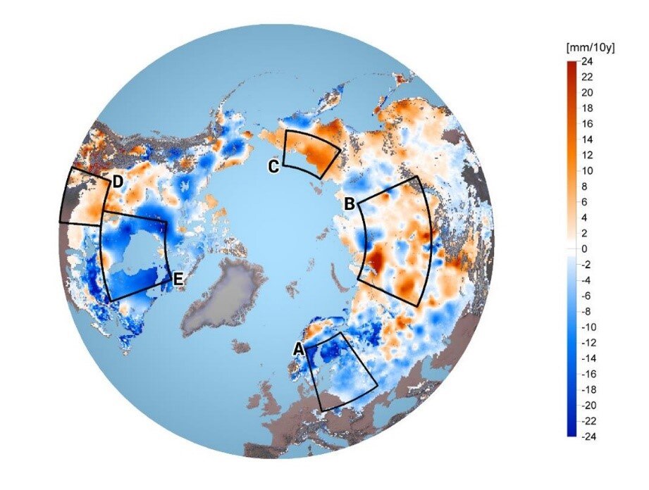
Changes in snow mass between 1980 and 2018
The combined 39-year snow mass climate data record is based on passive microwave satellite observations combined with ground-based snow depth measurements. This allowed the team to narrow the annual maximum snow mass for the northern hemisphere to 3062 gigatonnes between 1980-2018, with the peak snow mass occurring in March, while previous estimates ranged from 2500-4200 gigatonnes.
The team used this method, which corrects any anomalies in the data, and compared them to estimates from the Global Snow Monitoring for Climate Research, also known as GlobSnow, with three independent estimates of snow mass.
Jouni Pulliainen, the paper’s lead author and Research Professor at FMI, says, “The method can be used to combine different observations and it provides more accurate information about the amount of snow than ever before. The previous considerable uncertainty of 33% in the amount of snow has decreased to 7.4%.”
The research team found little reduction in northern hemisphere snow mass over the four decades of satellite observations when looking at the annual maximum amount of snow at the turn of February-March.
However, the more reliable estimates enabled the team to identify different continental trends. For example, snow mass decreased by 46 gigatonnes per decade across North America. This was not reflected in Eurasia, but high regional variability was observed.
Reduction of uncertainty in northern hemisphere seasonal snow mass
Jouni continues, “In the past, estimates of global and regional snowfall trends have only been indicative. The results show that the amount of rainfall has increased in the northern regions, especially in the northern parts of Asia.”
In northern areas, where rainfall generally turns to snow in winter, the snow mass has remained the same or even increased. In the southern parts, where in winter rainfall comes down as water rather than snow, both the extent of the snow cover and the snow mass have decreased.
Snow mass data have the potential to help scientists analyse and improve the reliability of models used to predict future change, however, previous attempts to estimate the amount of snow mass in northern latitudes are so varied that it is not possible to judge if changes have occurred with sufficient confidence.
The project team aims to continue developing the GlobSnow algorithm, as part of the ESA’s Climate Change Initiative – a research and development programme that merges and calibrates measurements from multiple satellite missions to generate a global time-series.
In November 2019, ESA Member States approved a major expansion of the Copernicus Sentinel fleet of satellite missions including CIMR – the Copernicus Imaging Microwave Radiometer candidate mission. To be launched no earlier than 2025, this multi-frequency microwave radiometer will provide high spatial resolution and high-fidelity measurements to continue and extent snow extent and mass records observation records into the future.
Co-author and member of the ESA CIMR Mission Advisory Group, Kari Luojus, adds, “The FMI team is already working to utilise the upcoming CIMR data for snow mass estimation, to further extend the long-term dataset.”


