Exploration of Space-borne LiDAR data for supporting Sentinel-1 Forest parameter retrieval
Forests provide a variety of functions such as being habitat for animals and plants, recreation area, source for renewable resources and offer protection and environmental functions. The objective of preserving and improving the efficiency of forests is in the public interest and can only be guaranteed, if planning and implementation of all respective measures are based on objective and reliable information on forest resources and condition. In general, forest can be described by properties that are stable over years (e.g. tree species) and highly dynamic properties, mainly caused by short-term events such as droughts, storm, snow damages or best infestations. To quantify these dynamic properties the temporal resolution of the available forest inventories (e.g. 6 years in Austria) is insufficient in terms of both, spatial and temporal resolution.
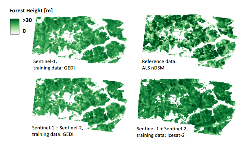
The key idea of SBL-S1-PR is to explore the potential of space-based Lidar (SBL) sensors for characterizing Alpine forests as found in Austria and to use the derived forest metrics as reference to calibrate forest canopy models based on Sentinel-1 data.
SBL-S1-PR lead to an improved understanding of potential SBL+S1 applications and therefore opened new research sectors such as large-scale change detection of forests with respect to 3D structure and biomass. The importance of such applications is reflected by the inclusion of forest biomass in the Global Stocktake, which is an integral part of the Paris agreement. Further applications arise from the relevance of forest structure for biodiversity. Biodiversity monitoring is set to be a priority field of action in the coming years at the national and international levels.