Feasibility study for using stereo Pléiades images for deriving 3D forest parameters for the entire Alpine space region
Mountain forests provide a wide range of ecosystem services in terms of protective, productive, social and economic functions. Additionally, they are a major factor in the CO2 balance and their change needs to be considered in international reporting. Therefore, a comprehensive knowledge of forest dynamics is required to monitor and better understand interactions between forests, human activities, and the atmosphere. Monitoring of forests is therefore of very high importance. To quantify the services provided, detailed knowledge of e.g. forest gaps, tree height, and crown coverage are required with high spatial and temporal resolution.
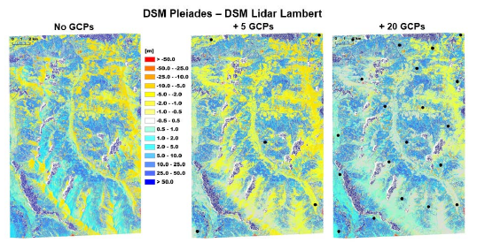
The knowledge gap to cross emerges because of the large area, roughly 200.000 km², which necessitates reliable, while still highly accurate, automated processing of large data sets. Satellite image orientation over large areas needs to be investigated, especially because ground control points cannot be assumed to be available.
The guiding idea to establish an Alpine Forest map, showing the important parameters at high resolution, shall be enabled by high resolution analysis, i.e. based on each individual tree crown in the uppermost crown layer. The specific aim of this exploratory project is to explore the possibility for generating such a map with satellite imaging technology.