Dengue MOdel Forecasting Satellite-based System
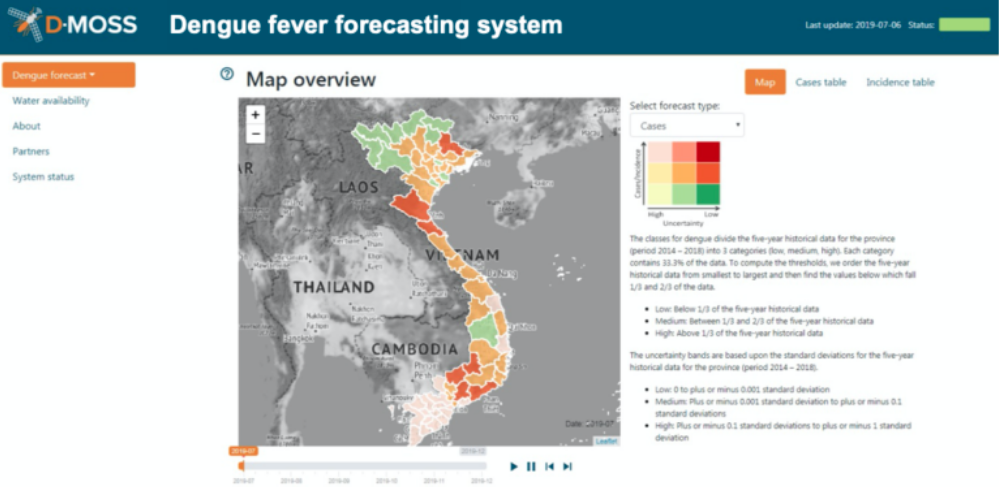
The Dengue MOdel forecasting Satellite-based System (D-MOSS) project is developing a dengue fever early warning system. The tool incorporates a variety of Earth observation (EO) data products ranging from historical observations to the latest state-of-the-art missions. Together with the UK Met Office seasonal forecasts (six-months lead time), D-MOSS draws on a set of freely available optical and radar EO data from GPM, Sentinel, SMOS, SMAP, and Aqua and Terra such as rainfall, temperature, humidity, soil moisture, land use, population density. These hydro-meteorological parameters are used to forecast dengue outbreaks and water availability. Key users of D-MOSS are government agencies such as the Ministry of Health or the Ministry of Environment for whom it provides information to formulate appropriate interventions and policies: The tool generates i) probabilistic forecasts of dengue outbreaks issued every month, up to seven months in advance at a district level, covering an entire country and ii) seasonal forecasts (six months) of water availability, covering the whole of the country at a catchment scale, which provides the additional benefit of improving water management in transboundary river basins