Flood Event Monitoring and Documentation enabled by the Austrian Sentinel Data Cube
Flooding is a recurrent phenomenon in Austria. Every year sees at least several smaller-scale flood events occurring in different parts of the territory. While the extent and duration of these events are limited, their combined impact on society and economy is significant. Unfortunately, field work to assess the flood status and its impact are time demanding and costly.
With state-of-the-art methods, as e.g. employed by the Copernicus Emergency Management Service, often fail to capture these small-scale flood events, the ACube4Floods project aims to extract the maximum information content from Sentinel-1 and Sentinel-2 data specifically for Austrian environment, applying change detection- and machine learning algorithms to analysis-ready Sentinel data cubes on a cloud platform. Furthermore, the project combines the satellite data with dynamic weather and mobile movement data in order to support flood documentation and near-real-time risk assessment. The project builds upon the Austrian Data Cube (ACube) that is envisioned to become an open governmental data service.
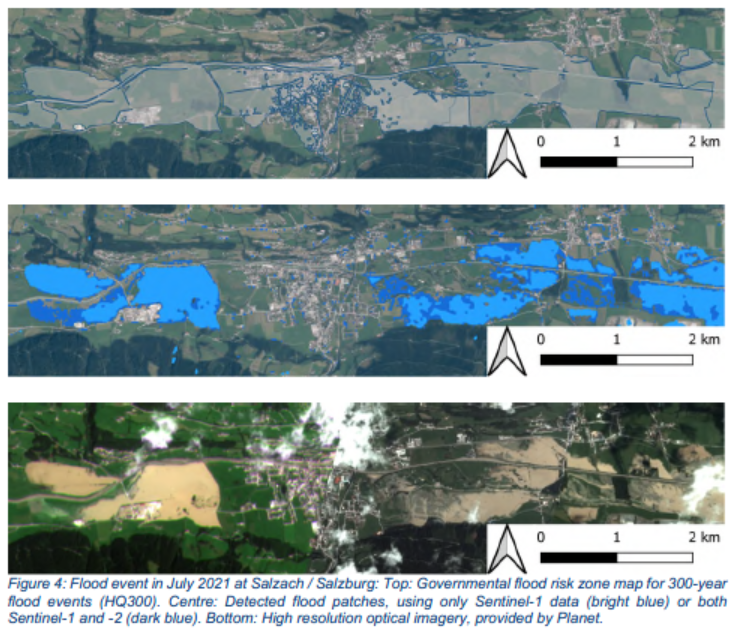
ACube4Floods helps the project’s pilot users, most importantly the Austrian Ministry for Sustainability and Tourism and the Federal Ministry of Defense, to enhance disaster resilience, through better preparedness, response, inventory and recovery by capturing also smaller-scale flood events. This involves e.g. the documentation and analysis of flood events, by which a comparison of the actual observed flood events with the simulated scenarios for certain occurrence probabilities from the hazard zone mapping can take place. Furthermore, ACube4Floods will combine Copernicus data with dynamic weather and mobile movement data in order to support near-real-time risk assessment.